
Oaxaca State Guide 2026: City, Coast & Sierra Norte
Oaxaca state covers 95,000 square kilometers of southern Mexico — roughly the size of Portugal — and contains three travel experiences so different from each other that most visitors never realize they’re all in the same state.
There’s the city: a UNESCO World Heritage colonial center at 1,550 meters elevation with Mexico’s most complex cuisine, a mezcal culture unlike anywhere else, and Monte Albán sitting above it all. There’s the coast: 500 kilometers of Pacific shoreline with powerful surf breaks, nesting sea turtles, bioluminescent lagoons, and beach towns that haven’t been smoothed into resort parks. And there’s the Sierra Norte: cloud forests, 8 Zapotec villages linked by 100 kilometers of mountain trails, and altitudes that’ll make your lungs notice.
Most people who “go to Oaxaca” experience only one of these. This guide is for the ones who want to understand all three — and plan accordingly.
The Three Oaxacas: City vs. Coast vs. Sierra Norte
Before booking anything, understand that these three zones feel like different countries. They’re geographically in the same state, but climate, culture, and infrastructure are completely distinct.
Oaxaca City sits in a highland valley at 1,550 meters. Days are warm (22-28°C), evenings cool down sharply, and the air is thin enough to feel. This is where you come for Zapotec and Mixtec history, the seven moles, mezcal bars, and one of the most intact colonial city centers in Mexico. Think cobblestones, jade-green churches, markets that smell of chocolate and dried chili.
The Pacific Coast is tropical — hot, humid in rainy season, and completely different from the Cancun-and-Riviera Maya experience most tourists know. Puerto Escondido has serious surf (Zicatela is one of Mexico’s top breaks). Mazunte has olive ridley sea turtles nesting on its beach from June through November. Zipolite is Mexico’s only legal nude beach. Huatulco has nine bays and a more organized tourism infrastructure. There’s no sargassum on the Oaxacan coast — that’s a Caribbean issue.
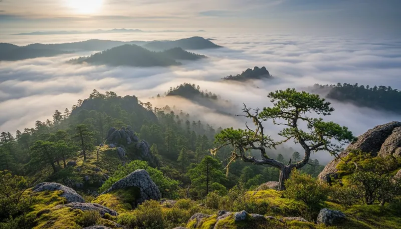
Sierra Norte / Pueblos Mancomunados is the least-known of the three and arguably the most extraordinary. Eight Zapotec villages at 1,900-3,100 meters elevation, connected by 100 kilometers of hiking and mountain biking trails through oak-pine and cloud forest. Mushroom tourism in rainy season. Temazcal steam baths in village cabins. Prices so low they feel like 2010. This is one of the most underrated outdoor experiences in Mexico.
How much time to allocate:
- Oaxaca City + Valley: 4-5 days minimum
- Pacific Coast: 3-5 days
- Sierra Norte: 2-3 days
- All three: 10-13 days total
Oaxaca City: Mexico’s Best Food City for Its Size
Oaxaca City has roughly 600,000 people in the metro area. For its size, no city in Mexico — arguably in Latin America — has a more complex and celebrated culinary tradition. The Oaxaca City guide covers the city in full depth; here’s what you need to know for the state overview.
The UNESCO Historic Center earned its designation for the integrity of its colonial architecture: the green stone Cathedral, the Templo de Santo Domingo (whose interior carved stone is Mexico’s most ornate), and a Zócalo main plaza that actually functions as a public square rather than a tourist stage. The city’s indigenous markets — Benito Juárez, 20 de Noviembre — remain working food markets, not tourist shops.
The Seven Moles
Oaxacan cuisine is defined by its seven moles: negro (the most complex, with chocolate, chilhuacle negro, and dozens of ingredients), rojo, coloradito, amarillo, verde, manchamanteles, and chichilo. Each has different chile bases, ingredient counts, and occasions. A good mole negro takes 3-4 days to make properly. The black mole at La Olla or Los Pacos is worth planning a meal around.
Beyond moles: tlayudas (large crispy tortillas with black bean paste, quesillo, and your choice of tasajo, cecina, or chorizo), chapulines (toasted grasshoppers, sold by street vendors and served in tacos), memelas, tetelas, and the city’s extraordinary chocolate tradition — Oaxacan cacao is what goes into the drinking chocolate at Mayordomo that locals have for breakfast.
Mezcal in Oaxaca
Oaxaca produces more mezcal than anywhere else in Mexico. The city has a mezcal bar scene that ranges from tourist-facing (large commercial bottles, no depth) to serious (palenqueros — mezcal producers — pouring single-origin, small-batch spirits from rare agave varieties like tobalá, tepeztate, and espadin selvaje). El Destilado and Boulenc bar are good starting points for the serious end.
For the production side: the Valles Centrales (Central Valleys) surrounding the city host dozens of palenques you can visit directly. Santa Catarina Minas produces mezcal using clay pots instead of copper — a technique that produces a different flavor profile. Most organized mezcal tours include a palenque visit.
Valley & Archaeological Sites: The Triangle
The Valley Triangle — Monte Albán, Mitla, and Hierve el Agua — is the standard day-trip circuit from the city. You can do each independently or combine two in a day with careful timing.
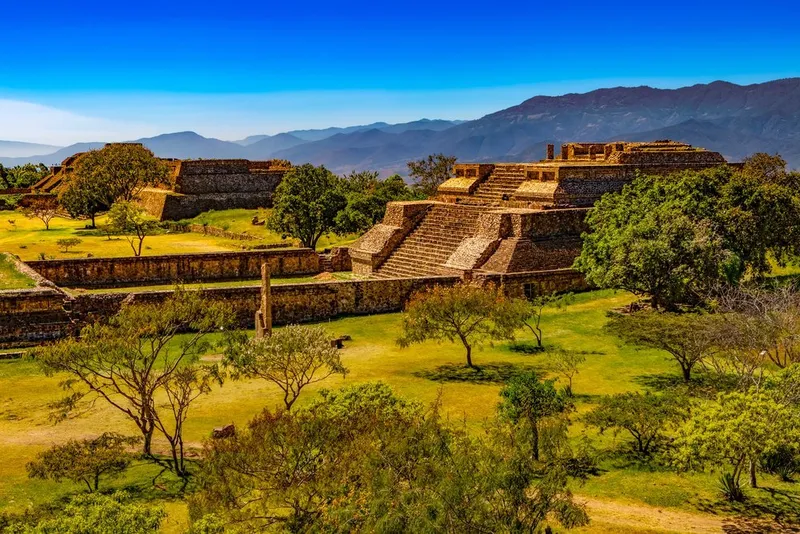
Monte Albán
Eight kilometers west of the city, on a flattened hilltop at 2,000 meters, Monte Albán was the capital of the Zapotec civilization for 1,500 years (500 BCE to 700 CE). At its peak it housed 25,000 people. The main plaza is enormous — 300 meters long — and oriented with the cardinal directions, with platforms, temples, and an observatory arranged around it.
What makes Monte Albán different from other Mexican ruins: the setting. You’re on a mountain above a valley, and the views in every direction are extraordinary. The Zapotec chose this location deliberately — it’s defensible, centrally positioned in the valley system, and ceremonially dominant. The astronomical knowledge encoded in the structures is remarkable: certain doorways align with sunrise and sunset on the equinoxes and solstices.
Go early (opens at 8 AM) before the tour buses arrive. Budget 2-3 hours. Colectivos from Calle Mina in the city run regularly; taxis cost about 150-200 MXN from the Zócalo.
Mitla
68 kilometers southeast of the city, Mitla was the Zapotec religious capital — the city of the dead in Zapotec cosmology. What distinguishes Mitla architecturally is the fretwork mosaic decoration on the palace walls: intricate geometric patterns made from thousands of individually cut stone pieces, set without mortar, with mathematical precision. There are 14 known geometric patterns across the site.
Combine Mitla with Hierve el Agua in a single day — they’re on the same road.
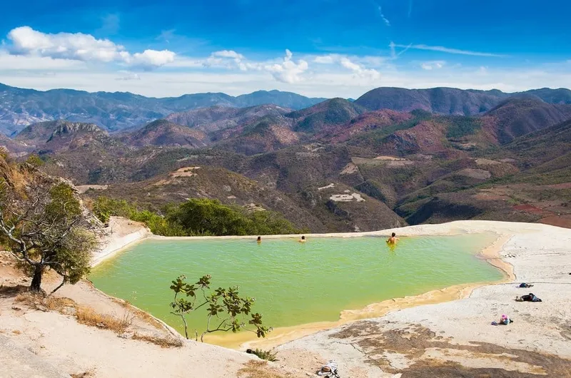
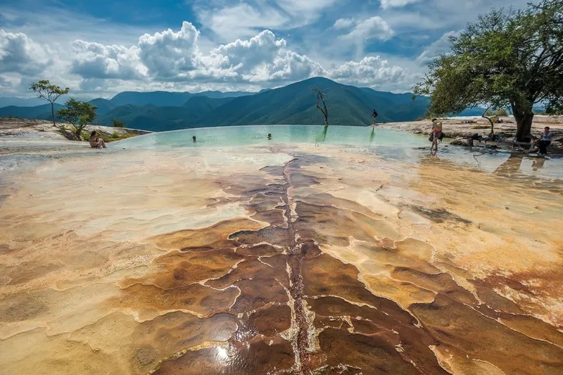
Hierve el Agua
One of Oaxaca’s most photographed sites: petrified waterfalls above a valley, with mineral-rich pools at the top. The calcium carbonate deposits have been building over thousands of years into the cascade shapes you see. The pools at the top have water between 20-25°C and overlook the valley below.
Getting there requires either a tour, rental car, or colectivo from Mitla (last colectivo back is around 4 PM — check this and don’t miss it). Admission is modest. Go on a weekday to avoid weekend crowds from the city.
Craft Villages: The Circuit
Within 30-50 kilometers of Oaxaca City, several villages specialize in crafts that have been passed down through Zapotec and Mixtec traditions for generations. You can do the circuit in a day with a car, or take organized tours.
Teotitlán del Valle (28 km east): Zapotec weaving village. Families have been making wool rugs and textiles on traditional looms for centuries. The geometric designs — often pre-Hispanic symbols adapted into contemporary patterns — are made with natural dyes: cochineal (the red from the scale insect that once made Spain rich), indigo, and marigold. Prices are fixed at workshops; bargaining is appropriate but not aggressive. Budget 800-3,000 MXN for a quality piece.
San Bartolo Coyotepec (12 km south): The source of the distinctive black pottery you see across Oaxaca. The black comes from a polishing technique applied before a low-oxygen firing — it’s not paint or glaze. Master artisan Doña Rosa is credited with rediscovering the shiny-surface technique in the 1950s. Her family’s workshop is still operating. Pieces range from small figurines (under 200 MXN) to large decorative vessels.
San Martín Tilcajete and Arrazola: These two villages compete for the title of alebrije capital. Alebrijes are the fantastical painted animal figures — jaguar with butterfly wings, gecko with snake patterns — that have become one of Mexico’s most recognizable craft exports. Both villages have workshops open to visitors; San Martín generally has the more elaborate contemporary pieces while Arrazola has the older tradition.
How to do the circuit: Rent a car or book a private tour for the day. Most circuits combine 2-3 villages with a mezcal palenque visit. Self-driving gives you control over timing — crucial since mornings at workshops mean you can see artisans at work rather than just shop.
Pacific Coast: No Sargassum, Sea Turtles, Real Surf

The Oaxacan Pacific coast is one of Mexico’s most underrated travel destinations — and increasingly discovered, which is changing the southern end faster than the northern end. The most important fact to communicate to anyone comparing coasts: there is no sargassum on the Oaxacan Pacific coast. That’s a Caribbean/Gulf problem. The Pacific coast also has no hurricane season impacts at the severity of the Caribbean.
For detailed beach coverage, see the best beaches in Oaxaca guide and the Puerto Escondido travel guide.
Puerto Escondido
The largest town on the coast, with genuine surf culture, a growing food scene, and enough infrastructure to be comfortable without being smoothed into a resort. Zicatela beach is a serious surf break — the Mexican Pipeline — and not swimmable for non-surfers. The protected Carrizalillo and Manzanillo beaches are calm and perfect for swimming. The bay at Puerto Angelito is the prettiest for snorkeling.
The Adoquín — the pedestrian strip in the tourist zone — has seafood restaurants, mezcal bars, and enough activity to stay interesting without overwhelming. For a full breakdown, see the Puerto Escondido guide.
Mazunte, Zipolite & San Agustinillo
Twenty-five to 30 kilometers west of Puerto Escondido: three small beach towns in rapid succession. Zipolite is the laid-back one — Mexico’s only legal nude beach, with a low-key hippie-traveler culture and cheap cabañas. San Agustinillo is the family-friendly middle option with calmer water. Mazunte is the wildlife town: the Centro Mexicano de la Tortuga (sea turtle center) is here, and the beach is a nesting site for olive ridley turtles from June through November. Watching a mass nesting — called an arribada — is one of the most extraordinary natural events in Mexico.
Huatulco
Further east, Huatulco is a planned tourism development with nine bays and 36 beaches. More organized infrastructure (better hotels, a functioning marina, organized diving) but less character than Puerto Escondido or Mazunte. Good for families, couples who want comfortable resort-adjacent facilities, and divers — the coral reefs here are the healthiest on the Oaxacan coast.
Getting to the Coast: The New Highway (Correct the 7-8 Hour Myth)
This is the most important practical correction in this entire guide.
Most travel articles — including major publications — still quote 7-8 hours from Oaxaca City to Puerto Escondido. That was true before 2024. The Autopista Barranca Larga-Ventanilla (Highway 135D) is now fully operational, and it reduces the journey to 3 to 3.5 hours.
The old route — the winding mountain road through San José del Pacífico — is still there. It takes 7-8 hours, passes through beautiful cloud forest, and is still used by local buses (OCC/ADO). But anyone driving or taking a modern shuttle should use the 135D.
Your options:
| Method | Time | Cost | Notes |
|---|---|---|---|
| Car rental (135D) | 3-3.5 hrs | 600-900 MXN toll + rental | Most flexible |
| Shared shuttle | 3.5-4 hrs | 500-700 MXN | Most popular tourist option |
| Flight (OAX-PXM) | 45 min flight / 3+ hrs total | 1,200-3,000 MXN | Add airport transfers |
| OCC/ADO bus | 7-8 hrs | 280-420 MXN | Old mountain road, budget option |
For car rental, compare agencies on RentCars — local Oaxacan agencies are often 30-40% cheaper than international chains and know the roads.
Sierra Norte & Pueblos Mancomunados
Sixty kilometers northeast of Oaxaca City, the Sierra Norte mountains rise above 3,000 meters. Eight Zapotec villages — Cuajimoloyas, Latuvi, Lachatao, Yavesía, Amatlán, Benito Juárez, La Nevería, and Llano Grande — form the Pueblos Mancomunados cooperative, sharing communal management of 27,000 hectares of forest.
The trail network covers 100 kilometers across oak-pine and cloud forest. Altitudes range from 1,900 to 3,100 meters. Mountain biking, hiking, zip-lines, and birdwatching are available at each village. The birds alone attract serious birders: resplendent quetzal has been spotted, along with hundreds of endemic and migratory species.
What makes this different from standard eco-tourism:
- Villages are actual functioning communities, not theme parks
- Accommodation is in village-run cabins (100-200 MXN per person per night)
- Food is home-cooked by village families (50-80 MXN per meal)
- Revenue stays in the community through the cooperative system
- Cloud forest mushroom tourism (June-September) is specific to this region — walking with local guides to identify edible mushrooms, which then get cooked into your dinner
The full hiking detail is in the Pueblos Mancomunados hiking guide.
Getting there: From Oaxaca City, take a colectivo toward Cuajimoloyas (the main entry village) from the bus terminal on Bustamante street — about 2 hours. Or rent a car. There are no tourist buses.
Practical note: The altitude is real. 2,500-3,100 meters is above what most people are acclimatized to if they’ve been in the city at 1,550m. Plan a day in the city first before heading up.
Getting Around Oaxaca State
The state is large and the three zones are separated by mountains. Public transport exists everywhere but operates on Oaxacan time — infrequent, sometimes unreliable, and routed for local needs rather than tourist circuits.
Within Oaxaca City: Walk, or take colectivo minivans (7 MXN) for anything over 20 minutes. Taxis are cheap (50-80 MXN for most city trips). Uber operates in the city.
Valley sites and craft villages: Organized tours (400-800 MXN per person) or rental car. Colectivos reach the main sites but require timing patience.
To the coast: Shuttle on the new 135D highway (recommended), or rental car if you want flexibility on the coast itself. Flying works for one-way trips (saves time on return).
The coast itself: Between Puerto Escondido, Mazunte, and Huatulco, colectivos and taxis operate frequently (50-150 MXN between towns). Car rental from Puerto Escondido airport gives you more freedom.
Sierra Norte: Rental car or colectivo from the city. No tourist transport.
RentCars compares local agencies — book in advance for December-January and Semana Santa when availability drops sharply.
Budget Guide by Zone
| Zone | Budget per day | Notes |
|---|---|---|
| Oaxaca City | 800-1,500 MXN | One of Mexico’s most affordable UNESCO cities |
| Valley day trips | +400-800 MXN | Tours included in city budget |
| Pacific Coast | 1,200-2,500 MXN | Puerto Escondido affordable; Huatulco pricier |
| Sierra Norte | 300-600 MXN | Village cabins + home-cooked food |
Oaxaca City specifics:
- Hostel dorm: 200-350 MXN
- Mid-range hotel: 800-1,400 MXN
- Tlayuda at Mercado 20 de Noviembre: 80-120 MXN
- Mezcal at a good bar: 80-180 MXN per pour
- Monte Albán admission: 90 MXN (Mexicans free on Sundays)
Coast specifics:
- Budget cabaña in Mazunte/Zipolite: 400-700 MXN
- Mid-range hotel in Puerto Escondido: 1,200-2,000 MXN
- Seafood meal on the beach: 150-250 MXN
Travel insurance that can work for travel in Mexico: travel insurance covers emergency medical, trip delays, and activities including surfing.
Best Time to Visit Oaxaca State
The state’s three zones have different optimal windows, but there are two periods that work well across all of them.
October–November: The Sweet Spot
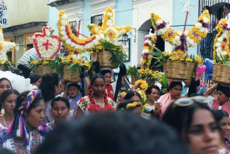
The rainy season ends in September-October, leaving the valleys green and the mountains cloud-heavy in a good way. Day of the Dead (November 1-2) in Oaxaca City and the surrounding villages is one of the most extraordinary cultural events in the Americas — elaborate altar preparations, cemetery candlelit vigils, marigold decorations. Book accommodation months in advance for this period.
The coast is transitioning out of rainy season — occasional afternoon rain but mostly clear. Sea turtle nesting at Mazunte peaks July-November, so October arrivals can still see turtle activity. Fewer tourists than December-January.
January–April: Dry Season Peak
Reliable weather everywhere: the city, the valleys, the coast, and the mountains. Best months for the coast (calm seas, no rain) and for valley hiking. Monte Albán is at its most photogenic January-February. Guelaguetza doesn’t happen, but you avoid the July humidity and rain.
Avoid: July-September for the coast and mountains if you dislike humidity and rain. The city is year-round excellent — the rainy season in the valleys just means afternoon showers, not all-day clouds.
Plan Your Oaxaca Trip
Essential Internal Links
- Oaxaca City Guide — full depth on the city: neighborhoods, restaurants, mezcal bars, day trips
- Puerto Escondido Travel Guide — surf breaks, beaches, accommodation, getting around
- Best Beaches in Oaxaca — Mazunte, Zipolite, Carrizalillo, Huatulco bays compared
- Best Time to Visit Oaxaca — month-by-month breakdown including festival calendar
- 5-Day Oaxaca Itinerary — the recommended first-timer sequence
Book Tours & Experiences
For guided experiences — mezcal tours, Monte Albán night tours, sea turtle watching, valley cooking classes — Viator’s Oaxaca collection has the widest selection of vetted operators with English-speaking guides.
Frequently Asked Questions
What are the three main travel zones in Oaxaca state?
Oaxaca state has three distinct zones that most visitors treat as separate trips: Oaxaca City (UNESCO colonial center, 7 moles, mezcal, Monte Albán ruins), the Pacific Coast (Puerto Escondido surf, Mazunte sea turtles, Huatulco bays, Zipolite nude beach), and the Sierra Norte (Pueblos Mancomunados cloud forest villages, 100km trail network, mountain biking at 1,900-3,100m). They’re all geographically in the same state but logistically separate — plan 10+ days if you want all three.
How long does it take to drive from Oaxaca City to Puerto Escondido?
The new Autopista Barranca Larga-Ventanilla (Highway 135D), fully operational since 2024, reduces the drive to 3-3.5 hours — not the 7-8 hours still quoted across most travel sites. Shuttle services using the new highway charge 500-700 MXN and are the easiest option. A flight takes 45 minutes in the air but 3+ hours total including airport transfers.
Is Oaxaca state safe for tourists in 2026?
The main tourist corridors — Oaxaca City, the Valley archaeological sites, the craft villages, Puerto Escondido, Huatulco, and the Pueblos Mancomunados — are safe for travelers. The US State Department rates Oaxaca at Level 2 (Exercise Increased Caution) due to criminal activity in parts of the Isthmus and certain highway corridors. Avoid isolated roads at night.
Do I need a car to explore Oaxaca state?
It depends on your zones. Oaxaca City is walkable. For the Valley triangle and craft villages, you can do organized tours. But for the Pacific coast and Sierra Norte, a rental car gives you real freedom. RentCars.com lists local agencies significantly cheaper than international chains; book at least a week in advance during peak season.
When is the best time to visit Oaxaca state?
October-November combines the best of everything: Day of the Dead celebrations, post-rainy season greenery, lower crowds than December, and comfortable temperatures. January-April is the dry season peak — reliable weather everywhere including the coast. July-August brings Guelaguetza festival but also the rainy season in the mountains.