Creel Chihuahua Travel Guide 2026: Copper Canyon Base Camp & Sierra Tarahumara
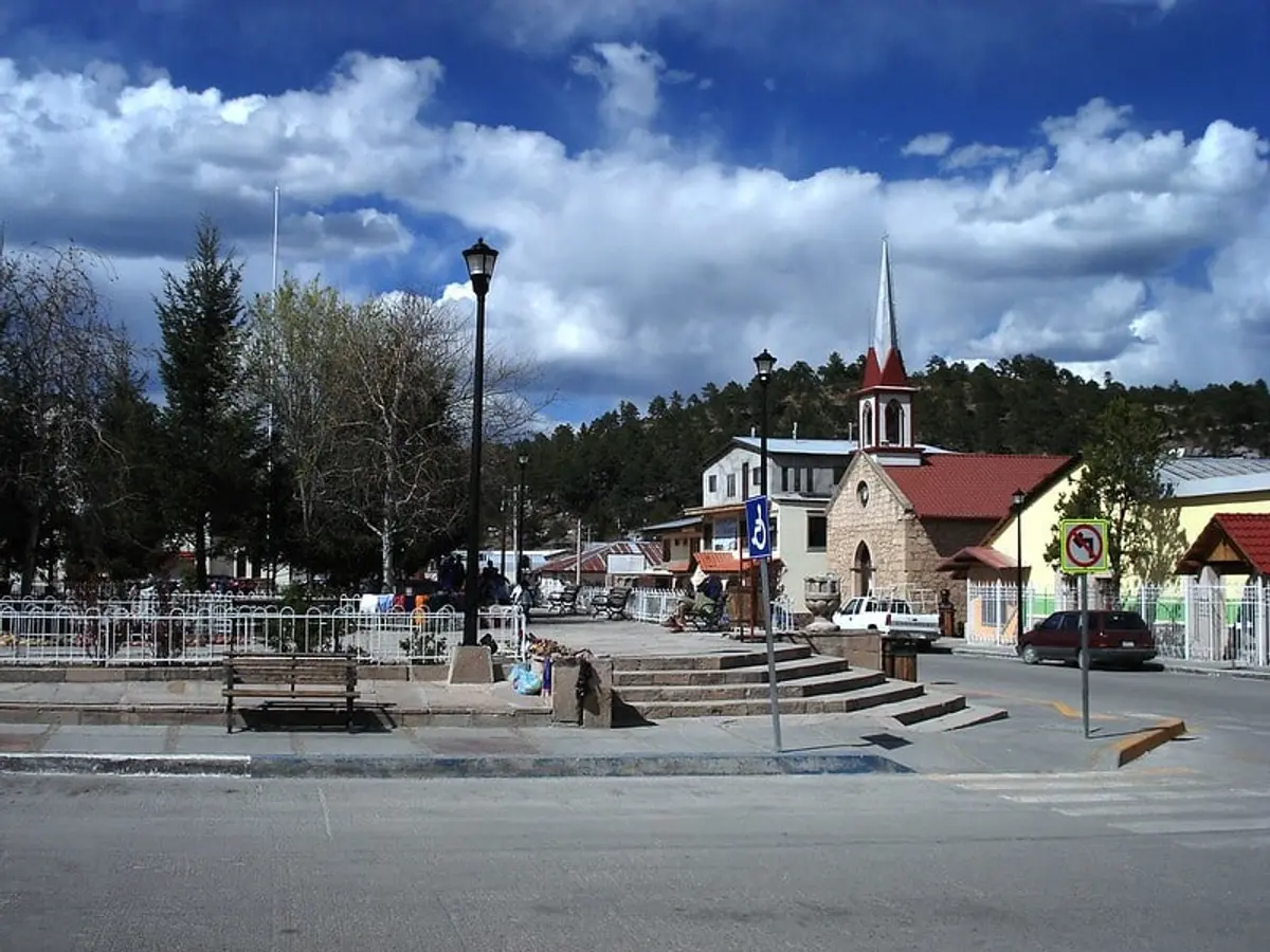
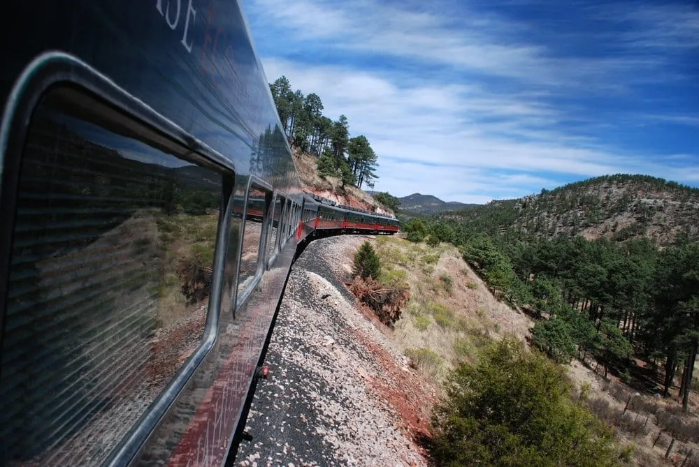
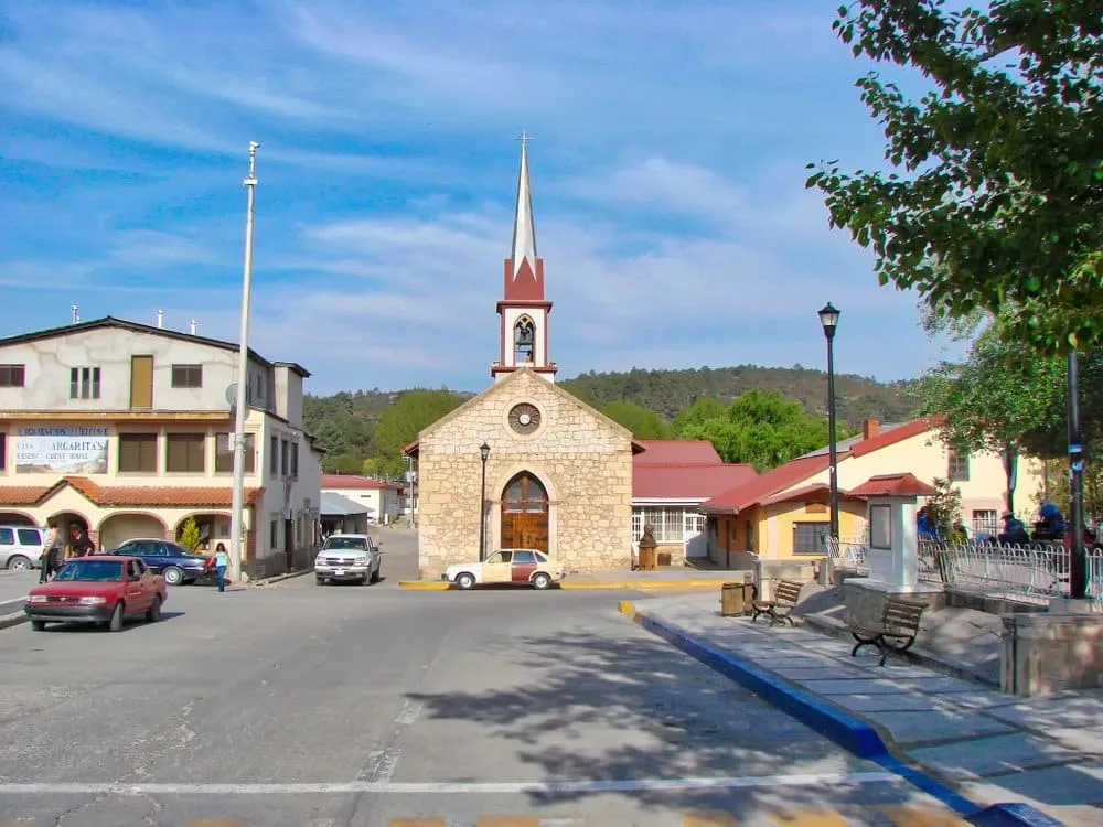
Creel (Estación Creel) is a Pueblo Mágico town of 6,000 people perched at 2,338 meters (7,670 ft) in the Sierra Madre Occidental of Chihuahua — the gateway town and main base camp for exploring the Copper Canyon system, Mexico’s answer to the Grand Canyon. It’s where El Chepe train stops mid-route, where Rarámuri people come to sell crafts, and where every canyon adventure begins.

| Altitude | 2,338m / 7,670 ft (pack warm layers year-round) |
| Distance from Chihuahua City | 260 km / ~3.5 hours by car or El Chepe |
| El Chepe stop | Yes — mid-route (both Express and Regional) |
| Population | ~6,000 (plus surrounding Rarámuri ejidos) |
| Pueblo Mágico | Yes (designation 2012) |
| Best time | May–October (waterfalls at peak, weather warm) |
| Budget | $40–$90 USD/day |
| Safety | Chihuahua Level 3 — tourist corridor is calm |
Why Visit Creel?
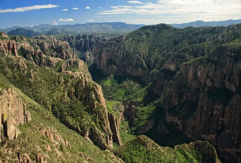
Creel is not just a town — it’s the logistics hub for one of Mexico’s most spectacular wilderness areas. The six canyons of the Copper Canyon system (Cañón del Cobre, Batopilas, Candameña, Chínipas, Sinforosa, Urique) fan out in every direction. Creel sits in the middle.
What makes Creel different from other Mexican destinations:
- Rarámuri (Tarahumara) people are a living presence — not a museum exhibit. They sell crafts in the market, live in the surrounding ejidos, and run several tourism cooperatives.
- El Chepe train stops directly in Creel, making it the natural break point for the 15-hour Chihuahua–Los Mochis route.
- No beach, no ruins — just pine forests, canyon views, waterfalls, and silence.
- The tourist circuit (Creel + Copper Canyon) is specifically safer than other parts of Chihuahua State. El Chepe trains run with no incidents. Tour operators have operated here safely for 30+ years.
Getting to Creel
By El Chepe Train (Recommended)
The Chepe Express and Regional trains both stop at Creel. This is the most scenic option and eliminates the driving stress.
| Route | Chepe Express | Chepe Regional |
|---|---|---|
| Chihuahua → Creel | ~3.5 hours | ~4.5 hours |
| Creel → Los Mochis | ~7 hours | ~9 hours |
| Departs Chihuahua | Tuesday, Thursday, Saturday | Monday, Wednesday, Friday, Sunday |
| Economy class fare (Chihuahua–Creel) | ~900 MXN ($45 USD) | ~600 MXN ($30 USD) |
| Express: Business / Tourist | ~1,900 / ~1,400 MXN | N/A |
Book at: chepe.mx — sells out in summer and holidays.
By Car from Chihuahua City
The 260km drive via Highway 16 (Cuauhtémoc route) takes 3.5 hours on paved road. Driving lets you stop at Mennonite villages in Cuauhtémoc and La Junta.
Compare car rental prices for Chihuahua City — pick up in Chihuahua, drive to Creel, return in Chihuahua or Los Mochis.
From Ciudad Juárez
~600 km south on Highway 45 to Chihuahua City, then Highway 16 west. Allow 8+ hours. The Chihuahua City → Creel section is the scenic part.
From the US Border (Ojinaga–Presidio, TX)
Ojinaga is the nearest US crossing, about 350 km from Creel. Scenic but long — cross at Ojinaga, head south to Chihuahua City, then west to Creel.
Top Attractions in Creel and the Sierra Tarahumara
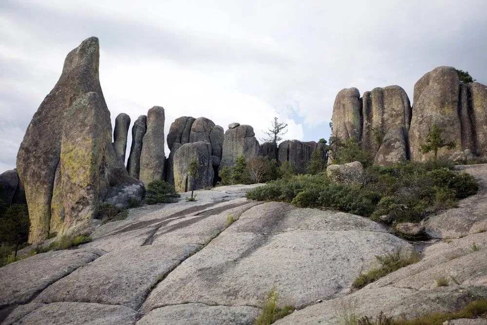
1. Valle de los Hongos (Valley of Mushrooms)
The most-visited attraction, just 7 km from Creel. Giant rock formations eroded into mushroom, frog, and monk shapes by millions of years of wind and water. It’s accessible by bike, ATV, or taxi — most visitors combine it with Lake Arareko (adjacent).
- Entry: ~50 MXN (paid to Rarámuri ejido)
- Time needed: 2–3 hours
- Best for: Photography, half-day trips
2. Lago Arareko (Lake Arareko)
A pine-forested lake on the outskirts of Creel, owned and managed by the Rarámuri ejido San Ignacio de Arareko. Rowboat rentals, lakeside cabins, and a hiking circuit around the lake. One of the best places to see the Sierra Tarahumara landscape without driving far.
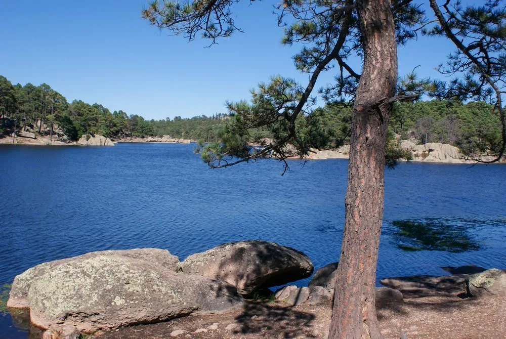
- Entry: ~50 MXN (goes directly to the Rarámuri community)
- Time needed: 2–4 hours
- Best for: Peaceful walks, nature photography
3. Valle de los Monjes (Valley of Monks)
Also called the Valle de los Dioses (Valley of the Gods), this area sits near the Valley of Mushrooms. Vertical rock formations rise 50 meters straight up, shaped by the Rarámuri into the profiles of monks and deities. Most memorable at golden hour.
4. San Ignacio Mission (Misión San Ignacio Arareko)
A working 18th-century Jesuit mission inside the San Ignacio de Arareko ejido, surrounded by a Rarámuri village of 20,000 hectares. An adjacent museum displays 45 colonial-era sacred paintings. This is active Rarámuri territory — visitors are welcome but treat it with respect.
5. Cascada Cusárare (Cusárare Waterfall)
23 km from Creel on the road toward Batopilas. This waterfall drops into a pine-canyon ravine and is considered one of the most beautiful in the Sierra Tarahumara. Trail from the parking area takes 30–45 minutes down, 50–60 minutes back up.
- Best time: Summer (May–October, peak water flow)
- Distance from Creel: 23 km (~30 min by car)
- Combo: Link with Batopilas road views
6. Recowata Hot Springs
20 km from Creel (12 km paved, 8 km rough track), then a 45-minute canyon descent on foot. These natural hot springs stay at 35°C year-round — remarkable because you hike down into the Tararecua canyon through spectacular cliff scenery to reach them. The contrast of cold canyon air and 35° water is intense.
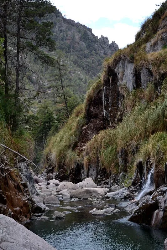
- Access: On foot (45 min down, 60 min back) — sturdy footwear required
- Best for: Adventurous visitors willing to hike for a reward
- Combo: Can camp overnight (bring gear)
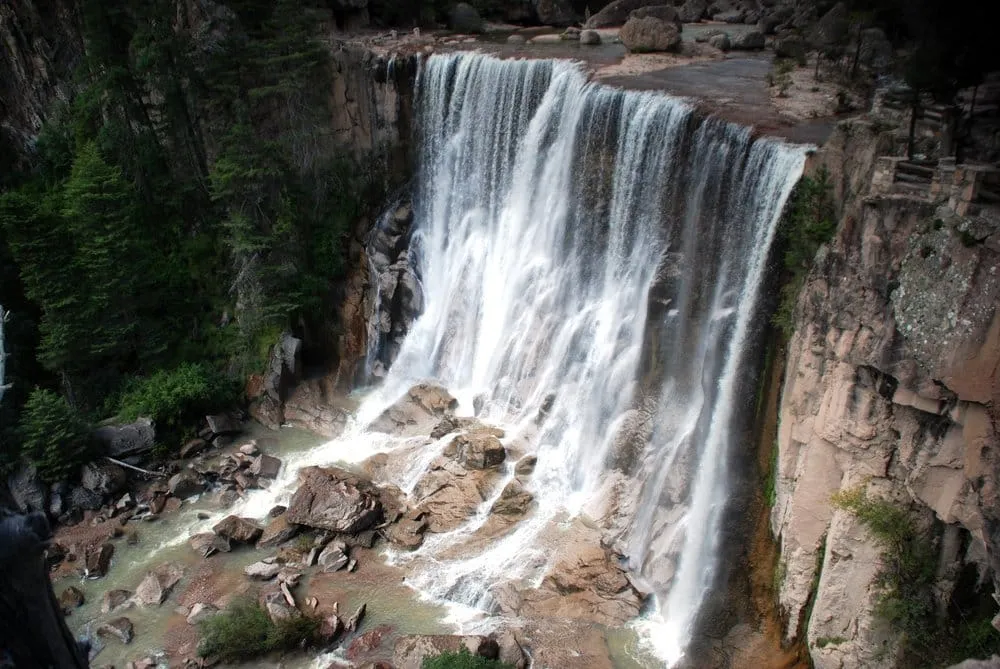
7. Candameña Canyon and Waterfall Circuit
The Candameña Canyon system (90 km from Creel) is home to two of Mexico’s most dramatic waterfalls:
| Waterfall | Height | Notes |
|---|---|---|
| Piedra Volada | 453 m | Tallest in Mexico, 11th in the world — seasonal (summer rain needed) |
| Basaseachi | 246 m | 5th tallest in the Americas — flows year-round, strongest Jul–Sep |
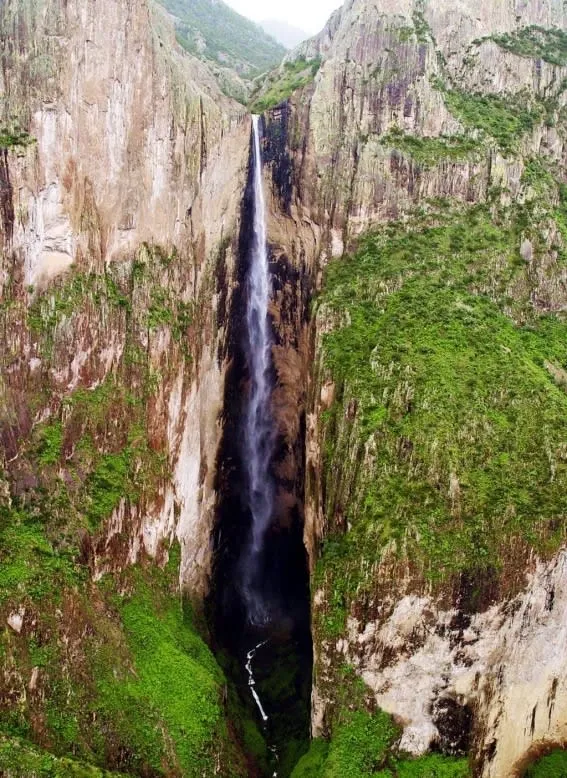
Basaseachi is accessible year-round. Piedra Volada only flows during and after heavy summer rains (July–September). Both are reached from the Basaseachi National Park entrance, 90 km northwest of Creel (~1.5 hour drive).
8. Creel Museum of Crafts (Casa de las Artesanías)
Based in the old train station (1956 building), this museum holds four permanent rooms covering Rarámuri ethnography, traditional tools, ceremonial objects, and folk art. The attached shop sells authentic crafts — far more reliable than street vendors for quality and fair-trade provenance.
9. Copper Canyon Viewpoints (Day Trips)
Creel sits above the canyon, not inside it. To see the canyon floor, you need to descend — which is what makes this area special. The Copper Canyon guide covers the full circuit. From Creel specifically:
- Divisadero Viewpoint: 90 km west on El Chepe — the classic canyon panorama shot. Take the train.
- Batopilas: 130 km south (5-hour descent on a spectacular mountain road) to the canyon floor village at 540m altitude — 1,800m lower than Creel.
Rarámuri Culture: What You Need to Know
The Rarámuri (Tarahumara) are one of Mexico’s largest indigenous nations, with 50,000–70,000 people living throughout the Sierra Tarahumara. Creel is their commercial hub — they come to town several days a week.
How to engage respectfully:
- Buy crafts directly from makers in the market (baskets, carved wood, woven textiles, pottery)
- Never photograph Rarámuri people without asking permission first (“¿Puedo tomar una foto?” — even then, some will decline)
- If you visit ejido lands (Lake Arareko, San Ignacio Mission), pay the entry fee — it goes directly to the community
- Don’t enter homes or ceremonial sites uninvited
- Many Rarámuri speak only their native language — Spanish is their second language too
Rarámuri running culture: The Rarámuri are legendary ultra-distance runners, capable of running 150–200 km in a single session. This isn’t a tourist attraction — it’s how they communicate across the canyon and hunt deer by pursuit over days. The Rarajípari ball-running ceremony (a competition) happens at Easter and Christmas. Respectful observers are sometimes welcome.
Day Trips from Creel
| Destination | Distance | Drive Time | Highlight |
|---|---|---|---|
| Valle de los Hongos + Arareko | 7–12 km | 15–20 min | Half-day, most popular |
| Cusárare Waterfall | 23 km | 30 min | Pine canyon waterfall |
| Recowata Hot Springs | 20 km + hike | 30 min + 45 min hike | Canyon thermal pools |
| Basaseachi Falls (246m) | 90 km | 1.5 hrs | 5th tallest in Americas |
| Divisadero viewpoint | 85 km | or El Chepe | Classic canyon panorama |
| Batopilas (canyon floor) | 130 km | 4–5 hrs | 1,800m descent, colonial village |
| Guachochi | 135 km | 2 hrs | Sierra Tarahumara Pueblo Mágico |
| Urique (canyon floor) | 150 km | 4–5 hrs | Deepest canyon in system |
For the full canyon circuit from Creel or starting in Chihuahua, see Day Trips from Chihuahua City.
Where to Stay in Creel
| Option | Price Range | Notes |
|---|---|---|
| Casa Margarita | $15–25 USD/person | Classic backpacker hostel, Rarámuri craft shop, tour booking |
| Hotel Parador de la Montaña | $60–90 USD/double | Best mid-range, log-cabin style, central |
| Copper Canyon Sierra Lodge | $100–150 USD | In pine forest near Lake Arareko, most atmospheric |
| Cabañas Las Arareko | $80–120 USD | Lakeside cabins on ejido land (community-owned) |
| Budget guesthouses | $25–40 USD | Several family-run options on the main street |
Book 4–6 weeks ahead for July–August, Easter, and Christmas/New Year.
Best Time to Visit Creel
| Month | Weather | Canyon | Waterfalls | Notes |
|---|---|---|---|---|
| Jan–Feb | Frigid (-20°C nights), snow possible | Snow on canyon rim | Low flow | Cold but dramatic. El Chepe runs. Bring serious gear. |
| Mar–Apr | Cold nights (0–5°C), warm days | Clear views | Moderate | Spring colors, Semana Santa crowds |
| May–Jun | Warm (15–25°C days), cool nights | Best clarity | Building | Ideal for hiking. Pre-rainy season. |
| Jul–Aug | Warm days, rainy afternoons | Green and dramatic | Peak flow | Best waterfall season. Book ahead. |
| Sep | Warm, rains tapering | Lush and green | Strong | Less crowded than July–Aug |
| Oct–Nov | Cool (5–15°C days) | Clear | Decreasing | Fall colors in the pine forest |
| Dec | Cold nights (-10 to -15°C), snow possible | Snow views | Low | Rarajípari ceremony at Christmas |
Best overall: May–September for hiking and waterfalls. July–August for peak waterfall flow. Avoid December–February unless you’re cold-weather prepared.
Food in Creel
Creel’s food scene is small-town northern Mexico, not a culinary destination — but the local staples are excellent.
What to eat:
- Carne asada: The Chihuahua obsession. Even in a small town, the asaderos are serious.
- Machacado: Dried beef, scrambled with egg — the regional breakfast.
- Arroz con leche + gorditas de harina: The classic northern sweet and breakfast bread.
- Apples and pine nuts: The Sierra Tarahumara produces both. Buy them fresh at the market.
- Rarámuri pinole: A roasted corn drink the Rarámuri use as trail fuel on long runs.
Where to eat in Creel:
- Restaurant Tío Molcas — the longest-running in town, reliable Mexican plates
- Market stalls near the train station — best for gorditas and machacado
- Hotel Parador de la Montaña restaurant — best sit-down dinner option
Budget Guide
| Budget Tier | Daily Cost (USD) | What You Get |
|---|---|---|
| Budget | $40–55 | Hostel or guesthouse, market meals, walk to Valley of Mushrooms, self-guided |
| Mid-range | $55–80 | Hotel, restaurant meals, guided tour (Valley circuit or Basaseachi), car rental |
| Comfort | $80–120 | Lodge with character (Sierra Lodge, Arareko cabins), guided multi-day canyon circuit |
Day tours from Creel: $25–60 USD/person (Valley of Mushrooms + Arareko, guided). Basaseachi waterfall day: $60–90 USD including transport. Batopilas overnight from Creel: $120–180 USD.
Safety in Creel
Chihuahua State carries a US Level 3 advisory, but the tourist corridor — El Chepe train, Creel, Copper Canyon, Batopilas — has a strong and consistent safety record.
The practical reality:
- El Chepe trains have run without incident for decades. The railway itself is safe.
- Creel’s town center is calm. Rarámuri families and tourist operators are the dominant presence.
- Tour operators and hotel staff know which roads are currently safe. Ask them before driving unfamiliar routes.
- The Chihuahua–Creel highway is paved and well-traveled. Avoid driving at night.
- Do not venture off established tourist routes without local guidance.
Travel insurance is worth considering here, especially a policy with emergency medical coverage and evacuation support.
Creel as Part of the Copper Canyon Circuit
Creel is the hub, not the destination. The full Copper Canyon experience builds outward from here:
- Arrive in Creel by El Chepe from Chihuahua City (morning train from Chihuahua)
- Day 1: Valley of Mushrooms, Lake Arareko, San Ignacio Mission
- Day 2: Basaseachi Falls (full day, 90 km drive)
- Day 3: Descend to Batopilas canyon floor (overnight recommended)
- Day 4: Return from Batopilas, depart on El Chepe toward Divisadero/El Fuerte/Los Mochis
See the complete route planner in the Copper Canyon travel guide.
Frequently Asked Questions
How many days do I need in Creel? Minimum 2 days to cover the main Valley of Mushrooms/Lake Arareko circuit and one major day trip (Basaseachi or Cusárare). Three days lets you descend to Batopilas canyon floor. Five days covers the full canyon circuit including Divisadero and a second descent.
Can I take the El Chepe train just to Creel and back? Yes. Buy a one-way ticket from Chihuahua to Creel (~900 MXN on the Express), spend 2–3 days, then return by train or rental car. Many visitors do this as a standalone trip rather than the full Chihuahua–Los Mochis crossing.
Is the Copper Canyon bigger than the Grand Canyon? By total area, yes. The Copper Canyon system covers 65,000 km² and includes 6 major canyons, compared to the Grand Canyon’s 4,930 km². The deepest point (Urique Canyon, 1,879m) is also deeper than the Grand Canyon’s deepest point (1,857m at Phantom Ranch).
What is the altitude of Creel, and will I feel it? Creel sits at 2,338m (7,670 ft). Most people feel mild altitude effects (headache, shortness of breath on exertion) for the first 12–24 hours. Drink water, avoid alcohol on the first night, and rest. The canyon floor at Batopilas (540m) provides a dramatic contrast.
When does the Piedra Volada waterfall actually flow? Piedra Volada (453m — tallest waterfall in Mexico) only flows during and after heavy summer rains. The safe window is late July through early September after several days of rain. Check with tour operators in Creel before driving 90 km to see it. Basaseachi (246m) flows year-round.
Plan Your Copper Canyon Trip
- Copper Canyon Mexico: Complete Guide — El Chepe schedule, all key stops, full circuit
- Chihuahua City Travel Guide 2026 — where to start, Pancho Villa Museum, getting to El Chepe
- Things to Do in Creel — full activities guide: Valle de los Hongos, Recowata hot springs, Basaseachi, craft market, and 15 more
- Things to Do in Chihuahua City — pre-canyon day before departure
- Day Trips from Chihuahua City — includes Paquimé + Copper Canyon overnight options
- Northern Mexico Travel Guide — broader regional context
Book canyon tours through Viator’s Copper Canyon selection — includes El Chepe packages, guided canyon descents, and Rarámuri cultural tours.
Compare car rentals for the Chihuahua → Creel route — RentCars often has better rates than airport counters for Chihuahua City.